• Skip to main content
  • Skip to primary sidebar
  • Skip to secondary sidebar
lizard

Moggill Creek

Catchment Group

  • Home
  • About MCCG
    • History Of MCCG
    • Catchment In Context
    • Governance
    • Benefits to our catchment
    • Projects
    • Why Do We Care
    • Volunteering
    • The Cottage
  • Get Involved
  • The Nursery
  • Events & Activities
    • Calendar Of Events
    • Projects
    • Cottage Talks
    • Kids’ Day
    • Working Bees
    • Photography Competition
    • Platypus Survey
    • Creek Health Monitoring
    • Private Land Rehabilitation
  • Catchment Field Guides
    • Birds common in our Catchment
    • Butterflies in our Catchment
    • Declared plants in our Catchment
    • Dragonflies in our Catchment
    • Freshwater fish in our catchment
    • Freshwater turtles in our catchment
    • Frogs in our Catchment
    • Ladybirds in our Catchment
    • Mammals in our Catchment
    • Rare and vagrant birds in our Catchment
  • Plants
  • Wildlife
    • Birds
    • Butterflies
    • Dung Beetles
    • Feral Animals
    • Koalas
    • Native Fish
    • Platypus
  • Landscape
    • The Creeks
    • Soils
    • Vegetation
    • Land Use
    • Geology
    • Land Restoration
  • Media Centre
  • News & Newsletters
    • Latest News
    • News Archive
    • MCCG Newsletters
  • Bush Bites
  • Reference Material
  • Useful Links
  • Membership
  • Contact MCCG

The Creeks

Moggill Creek rises in Brisbane Forest Park North West of Upper Brookfield and runs roughly southeast for 15kms to meet the Brisbane River, where it forms the boundary between the suburbs of Kenmore and Pinjarra Hills.

Moggill Creek’s main tributaries are Gold Creek, Wonga Creek, Gap Creek and McKay Brook. An unnamed tributary in the upper south west of the catchment follows Pacey road and joins Moggill Creek at the Upper Brookfield School. Wonga Creek is the local name for the tributary that runs adjacent to Savages Road, Brookfield and joins Moggill Creek just upstream of Bundaleer. Gold Creek also originates in Brisbane Forest Park, flowing through the Gold Creek Reservoir before joining Moggill Creek just downstream of Bundaleer. Gap Creek rises on the forested slopes of Mt Coot-tha and runs roughly adjacent to Gap Creek Road before merging with Moggill Creek just upstream of the intersection of Greentrees Avenue and Rafting Ground Road, Kenmore Hills. McKay Brook also rises in Brisbane Forest Park on Mt Coot-tha, joining Moggill Creek near Kenmore State High School.

The gradient of the creeks from the high catchment boundaries is very steep down to the junctions of Moggill creek and its tributaries.

These gradients result in high velocity runoff in the un-named creek near Pacey road in Upper Brookfield, and in Gap creek and Wonga creek down as far as their junctions with Moggill Creek. Gold Creek runoff is moderated by the Gold Creek Reservoir, but runoff velocities resulting from episodic rainfall events can still be quite rapid and dangerous on all road culverts down as far as Adavale Street and the junction with Moggill Creek. These rapid runoff events can cause severe damage to creek banks and beds, and are a major challenge for landholders and others attempting to revegetate private and public lands.

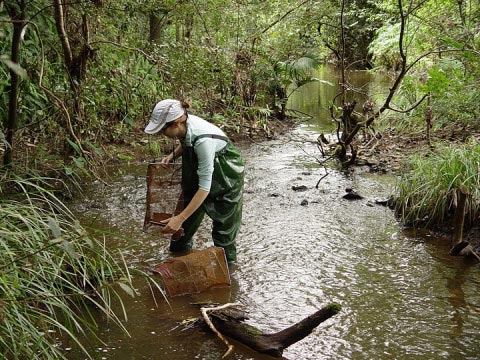
Recent creek health monitoring at 12 sites across the catchment have indicated that aquatic ecosystems of creeks within the Moggill Creek catchment were in good condition with relatively good diversity of sensitive and tolerant macro invertebrate species in most sites.

Riparian zone conditions from the upper catchment down to the major gradient change for all creeks tend to be better than those for the lower part of each creek. There are examples of quite degraded riparian conditions in terms of vegetation width, creek overhang, and diversity of native species, ingress by exotic trees, shrubs and vines and in bank stability. Total clearing to the stream banks has occurred in many of these lower reaches, and the in-stream habitat has suffered markedly through lack of large woody debris, sedimentation of deep pools, runs and riffles, and infestations of exotic aquatic weeds. In some sites where stream cover and width of vegetation zone is satisfactory, exotic species predominate. Despite these limitations, water quality assessments carried out regularly over the last 20 years, the water quality of Moggill Creek and its tributaries have generally met the Queensland Water Quality guidelines for all the indicators assessed, and been classed as typical of an undisturbed waterway. The occasional low dissolved oxygen levels are regarded as natural for ephemeral streams.

Return to Landscape

Primary Sidebar

In This Section

  • Landscape
  • The Creeks
  • Soils
  • Vegetation
  • Land Use
  • Geology
  • Land Restoration
Get  Involved!
MCCG on Facebook MCCG on Facebook

Secondary Sidebar

  • Home
  • About MCCG
    • History Of MCCG
    • Catchment In Context
    • Governance
    • Benefits to our catchment
    • Projects
      • Old Gold Creek Sawmill Forest Walk
      • Anzac Tree Daisy Project
      • Bird Project
      • Bird Project – Deerhurst Street Park
      • Creek Health Monitoring
      • Pacey Road
      • Rowena Street Park Restoration Project
      • Streamsavers
      • Smith’s Scrub
    • Why Do We Care
    • Volunteering
    • The Cottage
  • Get Involved
  • The Nursery
  • Events & Activities
    • Old Gold Creek Sawmill Forest Walk
    • Calendar Of Events
    • Projects
    • Cottage Talks
    • Kids’ Day
    • Working Bees
    • Photo Competition
    • Platypus Survey
    • Creek Health Monitoring
    • Private Land Rehabilitation
  • Catchment Field Guides
    • Birds common in our Catchment
    • Butterflies in our Catchment
    • Declared plants in our Catchment
    • Dragonflies in our Catchment
    • Freshwater fish in our catchment
    • Freshwater turtles in our catchment
    • Frogs in our Catchment
    • Ladybirds in our Catchment
    • Mammals in our Catchment
    • Rare and vagrant birds in our Catchment
  • Plants
  • Wildlife
    • Birds
    • Butterflies
    • Dung Beetles
    • Feral Animals
    • Koalas
    • Native Fish
    • Platypus
  • Landscape
    • The Creeks
    • Soils
    • Vegetation
    • Land Use
    • Geology
    • Land Restoration
  • Media Centre
  • News & Newsletters
    • Latest News
    • News Archive
    • MCCG Newsletters
  • Bush Bites
  • Reference Material
  • Useful Links
  • Membership
  • Contact MCCG

© MOGGILL CREEK CATCHMENT MANAGEMENT GROUP INC.
ABN 57 981 459 029
ALL RIGHTS RESERVED | PRIVACY POLICY | CONTACT US

ACNC-Registered-Charity-Logo_RGB

Proudly supported by

aus-gov-logo
BCC-Logo-ILoveBNE

© MOGGILL CREEK CATCHMENT MANAGEMENT GROUP INC.
ABN 57 981 459 029
ALL RIGHTS RESERVED | PRIVACY POLICY | CONTACT US

Proudly supported by

supported-by